CONTENT
INTRODUCTION.. 3
CHAPTER I DEFINITION OF CONTINENT AND ITS HISTORY.. 5
1.1 Number of continents. Separation of continents. 5
1.2 History of the concept 9
1.3 Geology. 12
CHAPTER II CONTINENTS OF THE WORLD.. 15
2.1 Asia. 15
2.2 Africa. 16
2.3 North America and South America. 18
2.4 Antarctica. 20
2.5 Europe. 22
2.6 Australia. 24
CHAPTER III BOUNDARIES BETWEEN CONTINENTS. 26
3.1 Europe and Asia. 26
3.2 Landlocked countries. 30
CONCLUSION.. 33
BIBLIOGRAPHY.. 35
CHAPTER I DEFINITION OF CONTINENT AND ITS HISTORY
1.3 Geology
...
Some argue that continents are accretionary crustal "rafts" that, unlike the denser basaltic crust of the ocean basins, are not subjected to destruction through the plate tectonic process of subduction. This accounts for the great age of the rocks comprising the continental cratons. By this definition, Eastern Europe, India and some other regions could be regarded as continental masses distinct from the rest of Eurasia because they have separate ancient shield areas (i.e. East European craton and Indian craton). Younger mobile belts (such as the Ural Mountains and Himalayas) mark the boundaries between these regions and the rest of Eurasia.
There are many microcontinents, or continental fragments, that are built of continental crust but do not contain a craton. Some of these are fragments of Gondwana or other ancient cratonic continents: Zealandia, which includes New Zealand and New Caledonia; Madagascar; the northern Mascarene Plateau, which includes the Seychelles. Other islands, such as several in the Caribbean Sea, are composed largely of granitic rock as well, but all continents contain both granitic and basaltic crust, and there is no clear boundary as to which islands would be considered microcontinents under such a definition. The Kerguelen Plateau, for example, is largely volcanic, but is associated with the breakup of Gondwanaland and is considered a microcontinent, whereas volcanic Iceland and Hawaii are not. The British Isles, Sri Lanka, Borneo, and Newfoundland are margins of the Laurasian continent—only separated by inland seas flooding its margins.
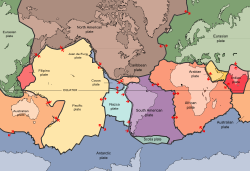
Plate tectonics offers yet another way of defining continents. Today, Europe and most of Asia constitute the unified Eurasian Plate, which is approximately coincident with the geographic Eurasian continent excluding India, Arabia, and far eastern Russia. India contains a central shield, and the geologically recent Himalaya mobile belt forms its northern margin. North America and South America are separate continents, the connecting isthmus being largely the result of volcanism from relatively recent subduction tectonics. North American continental rocks extend to Greenland (a portion of the Canadian Shield), and in terms of plate boundaries, the North American plate includes the easternmost portion of the Asian land mass. Geologists do not use these facts to suggest that eastern Asia is part of the North American continent, even though the plate boundary extends there; the word continent is usually used in its geographic sense and additional definitions ("continental rocks," "plate boundaries") are used as appropriate.
The movement of plates has caused the formation and break-up of continents over time, including occasional formation of a supercontinent that contains most or all of the continents. The supercontinent Columbia or Nuna formed during a period of 2.0–1.8 billion years and broke up about 1.5–1.3 billion years ago.[8] The supercontinent Rodinia is thought to have formed about 1 billion years ago and to have embodied most or all of Earth's continents, and broken up into eight continents around 600 million years ago. The eight continents later re-assembled into another supercontinent called Pangaea; Pangaea broke up into Laurasia (which became North America and Eurasia) and Gondwana (which became the remaining continents).
CHAPTER II CONTINENTS OF THE WORLD
2.4 Antarctica
... The geological study of Antarctica has been greatly hindered by the fact that nearly all of the continent is permanently covered with a thick layer of ice. However, new techniques such as remote sensing, ground-penetrating radar and satellite imagery have begun to reveal the structures beneath the ice.
The main mineral resource known on the continent is coal. It was first recorded near the Beardmore Glacier by Frank Wild on the Nimrod Expedition, and now low-grade coal is known across many parts of the Transantarctic Mountains. The Prince Charles Mountains contain significant deposits of iron ore. The most valuable resources of Antarctica lie offshore, namely the oil and natural gas fields found in the Ross Sea in 1973. Exploitation of all mineral resources is banned until 2048 by the Protocol on Environmental Protection to the Antarctic Treaty [15].
Some of Antarctica has been warming up; particularly strong warming has been noted on the Antarctic Peninsula. A study by Eric Steig published in 2009 noted for the first time that the continent-wide average surface temperature trend of Antarctica is slightly positive at >0.05 °C (0.09 °F) per decade from 1957 to 2006. This study also noted that West Antarctica has warmed by more than 0.1 °C (0.2 °F) per decade in the last 50 years, and this warming is strongest in winter and spring. This is partly offset by fall cooling in East Antarctica. There is evidence from one study that Antarctica is warming as a result of human carbon dioxide emissions. However, the small amount of surface warming in West Antarctica is not believed to be directly affecting the West Antarctic Ice Sheet's contribution to sea level. Instead the recent increases in glacier outflow are believed to be due to an inflow of warm water from the deep ocean, just off the continental shelf. The net contribution to sea level from the Antarctic Peninsula is more likely to be a direct result of the much greater atmospheric warming there.
A study published in the sixth edition of the Nature Geoscience journal in 2013 (published online in December 2012) identified central West Antarctica as one of the fastest-warming regions on Earth. The researchers present a complete temperature record from Antarctica's Byrd Station and assert that it "reveals a linear increase in annual temperature between 1958 and 2010 by 2.4±1.2 °C". At the time that the research was published, the American researchers were affiliated with The Ohio State University, the National Center for Atmospheric Research and the University of Wisconsin-Madison. ...
BIBLIOGRAPHY
1. National Geographic. Retrieved 2009-08-22. "Most people recognize seven continents—Asia, Africa, North America, South America, Antarctica, Europe, and Australia, from largest to smallest—although sometimes Europe and Asia are considered a single continent, Eurasia."
2. Honour, Hugh, The New Golden Land: European Images of America from the Discoveries to the Present Time. New York: Pantheon Books, 1975. An exhibition based on the book's premise was curated by Honour at the Cleveland Museum of Art, 1975-77.
3. Fleming, E. McClung, "The American Image as Indian Princess, 1765-1783," Winterthur Portfolio 2 (1965): 65-81. ...